Cissbury Ring: Yellowhammers; Linnets; Goldfinches; Stonechats, 30.06.21
- Sim Elliott

- Jul 1, 2021
- 6 min read
Updated: Jul 2, 2021
Cissbury Ring (Natural Trust) is just north of Worthing and east of Findon.
How to get to Old Lodge by bike:
I reached Cissbury Ring by cycling to Broadwater in Worthing, parking my bike in Cissbury Road. I crossed the A27 (Upper Brighton Road) and then walked though the Rotary/Hill Barn Recreation Ground. At the top of the recreation ground I waked east up Hill Barn Lane, until reaching the bridleway on the left that takes you due North to Cissbury Ring. To the left (west) of the loath is the Hill Barn Gold Course. This walk takes about 1 hour (going up to Cissbury Ring); and about 45 minutes (on the return). It is possible to cycle up the bridleway to Cissbury Ring, but it is a very steep bridleway.
How to get to Old Lodge by public transport:
If you wanted to reach Cissbury Ring by public transport you can get the the Stagecoach 700 bus to Worthing (from Brighton or Shoreham) and get off at Marine Parade. Bus frequency: every 10 minute; journey time (from Brighton): 60 minutes. Click here for the 700 timetable. Then walk about 200m to the Worthing South Street stop (Stop J) and catch the Stagecoach 1 bus (direction: Midhurst). You could either get off at Broadwater, Cricketers Parade, and walk up Cissbury Road, and follow the walking route outlined above. Alternatively, you could get off at Findon Valley, May Tree Avenue, and walk there much shorter distance to Cissbury Ring from there. Bus frequency: once an hour, Monday-Saturday; once every two hours Sundays; journey time: 10 minutes (Worthing South Street to Broadwater:); 25 minutes. Click here for the 1 timetable.
All text in italics are quotations; sources given.
The photographs are in chorological order

Walking route shown in orange; Google maps: https://goo.gl/maps/drGhtwiGmsGc4CLH8

Arial view of Cissbury Ring from National Trust site: Cissbury Ring | National Trust
The history of Cissbury Ring is fascinating. The following information is from the National Trust's website
Prior to the Neolithic period human activity was limited here. Bands of hunters are thought to have used the South Downs as a vantage point for spotting animal herds.
The Neolithic period saw the development of settlements in the surrounding area as people banded together to clear woodland, plant crops and domesticate animals. An extensive flint mining operation was carved out on the southern side of the hill evidence of which can still be seen today.
The Iron Age hill fort was constructed around 400BC and was used for defence for around 300 years. Cissbury is a univallate fort, that is a hilltop enclosure with a single rampart accompanied by a ditch and a low counterscarp bank. The hill fort encloses around 26 hectares and originally had only two entrances, one at the eastern corner and the other at the southern end.
After 100BC the interior of the fort was used for agriculture with rectangular fields being marked out with earthwork banks and terraces.
There is archaeological evidence of a settlement at Cissbury during the later Roman period. This comprised a group of 11 buildings and two rectangular enclosures situated near the eastern entrance to the fort. The ramparts were heightened at this time possibly in fear of Danish attacks.
The discovery at Cissbury of two successive issues of coinage struck between AD1009 and AD1023 suggests that there was once a mint here.
There is little evidence of activity here during medieval times but many of the local agricultural trackways across the downland are likely to have originated during this period.
Agricultural settlements continued to grow during the early Bronze Age when Cissbury appears to have been used as a ritual burial ground. Two round barrows have been identified here. This type of burial mound marked a change from multiple interments in a long barrow to individual burials.
In Tudor times Cissbury formed part of an early-warning system of beacons that ran the length of the south coast. Watchers were able to monitor 78 miles of coastline from here. The beacons consisted of barrels of pitch on top of tall oak posts.
Though recognised as having defensive capabilities several times since then, no actual military activity took place on the hill until the Second World War. A large anti-tank ditch was excavated around the entire hill in 1940 and anti-aircraft guns were positioned across the highest part of the ridge within the hill fort.
Later in the war the north slope of Cissbury Hill was used in military exercises in preparation for the invasion of Europe. Observation dugouts were excavated within the rampart to accommodate machine-gun posts. The story of Cissbury Ring | National Trust
Cissbury Ring in the distance (on the horizon), from lower down the footpath, across Hill Barn Golf Course
The Bridleway to Cissbury Ring

The bridleway to Cissbury Ring

Hairy Vetch beside the bridleway

A Woodpigeon. Woodpigeons are so commo (one of the UK's most common birds) that their beauty is often overlooked.

Carrion Crows on a fence, east of the bridleway, approaching Cissbury Rung

Saint John's Wort beside the bridleway

An Ash Tree (I think)

This a fledgling Whitethroat. Whitethroats are summer visitor and passage migrant. They winter in Africa, south of the Sahara. This Whitethroat will make its Maiden flight to Africa probably mid October. To get there it will use an innate ability to imitate it's fellow Whitethroats in migration, acquiring a neurological visual and olfactory representation ("map") of the route, that it can use to return next year. It may also perceive (through a sense not yet fully understood) the "feel" of southness, from the earth's magnetic field. There is a very interesting Radio 4 In Our Time programme on bird migration. Click here to listen to it.


I saw a Yellowhammer from the bridleway too.

in this tree

The bridleway


This tree (another Ash I believe), possibly with Ash die-back) can be seen at on the horizon of the first photograph

Dog Rose at the side of the Bridleway

Cissbury Ring (south) from the Bridleway.

Cissbury Ring (south) from the Bridleway.

The path through the ramparts (south eat corner of the fort)

A juvenile Blacbird.

A Yellowhammer (I think a female).

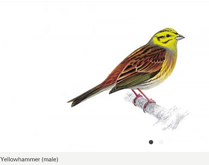
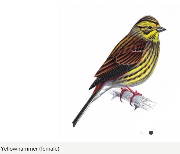
Male and female Yellowhammers from Yellowhammer Bird Facts | Emberiza Citrinella - The RSPB


A Linnet silhouetted against the sky.

A fledgling Robin


Linnets and a Yellow Hammer having a bath in a muddle puddle.


The yellowhammer is a sparrow-sized, bright yellow bird of woodland edges, hedgerows, heath and farmland that feeds on seeds and invertebrates. In the winter, it will join mixed flocks of buntings, finches and sparrows to feed on seeds on farmland. Yellowhammers are often seen perched on top of bushes singing their 'a little bit of bread and no cheese' song. The female builds a cup-shaped nest from grass and moss, laying between two and six eggs. Yellowhammer | The Wildlife Trusts Red conservation status
A common, small finch of heathland, scrub and farmland, the linnet feeds on seeds and is present in the UK all year-round. In winter, they may form large flocks with other seedeaters, roaming the countryside and feeding on stubbles, saltmarshes and wasteland. Linnets build neat, bowl-shaped nests, often in gorse bushes or in hedgerows. They were once popular cage birds due to their melodious song Linnet | The Wildlife Trusts Red conservation status


Another male Yellowhammer


The ramparts - west.

A Linnet

Birds Foot Trefoil and other download plants

A raptor; I initially thought this was a Buzzard but I think it is probably a Kestrel.


A Goldfinch


More Goldfinches, adults and juveniles


A Linnet

More Goldfinches, adults and juveniles.

Goldfinches and a Linet


A Linet


A Blackbird

A fledgling Stonechat and an adult male Stonechat with food (for the fledgling).


Father Linnet levaes

Fledgling calls ("food"!)

Another Linnet


The triangulation point (set up by the Ordnance Survey)


Heal-all

One of the back-filled flint mines

Flint mining took place at Cissbury Hill during the Neolithic period long before the construction of the hill fort. Thanks to Victorian archaeologists we know that there are substantial surviving underground shafts and galleries here. In the 1970s radiocarbon dating on material from all Britain’s flint mines showed that mines in Sussex were the earliest in the country. Neolithic flint mines at Cissbury Ring | National Trust
... one of the more interesting figures to explore Cissbury was a local working class self-taught archaeologist named John Pull. He'd already achieved notoriety in the area following his discoveries at Blackpatch in the early 1920s and suffered at the disparaging hands of the Worthing Archaeology Society for his methods and site recording procedures. Most of this was down to pure snobbery on the Society's part and given the towns Conservative nature hardly surprising. He did however rejoin the Society in 1947, taking over as president in 1952 and started new works at Cissbury the same year which gave rise to the most comprehensive studies of the Cissbury mines ever undertaken. Sadly he was shot dead in a bank raid in 1960 while working as a security guard at the Durrington branch of Lloyds Bank. Cissbury Ring Hillfort – The Modern Antiquarian.com


Comments