Kingley Vale National Nature Reserve. Ancient Yews, Iron-Age Monuments & Butterflies. 21.05.22
- Sim Elliott

- May 25, 2022
- 12 min read
Updated: Jun 20, 2022
This must be where the Ents live, where dryads play and fairies sleep under toadstools — yet it is only three miles from the coastal city of Chichester.
A walk through these ancient, twisted yews, which are among the oldest living things in Britain with trunk girths of up to 16ft, is an enchanting rarity.
Annunciata Elwes, January 15, 2021, Kingley Vale, West Sussex: The ancient, twisted yews that are the oldest living things in Britain, Kingley Vale, West Sussex: The ancient, twisted yews that are the oldest living things in Britain - Country Life
I had wanted to go to Kingley Vale for a long time as I had heard of the beauty of the ancient Yews, see Kingley Vale - Woodland Trust, and also because it is well-known for its butterfly abundance and diversity: of the 58 species of butterfly that breed in England, 39 have been recorded at Kingley Vale, including chalkhill blue, holly blue and brimstone. Kingley-Vale-Hidden-Trail-Final-web-version.pdf (southdowns.gov.uk). The Kingley Vale area is also known for its Iron Age ancient monuments, including the Devil's Humps and Goosehill camp
This post is split into the following sections
- getting to Kingley Vale from Funtington via Stoke Wood and the Devil's Ditch
- Yews
- Goosehill Camp
- Butterflies
- Other insects
- Birds
- the Devils Humps
- the journey back to Chichester via the River Levant and the Centurion Way
Getting to Kingley Vale from Funtington via Stoke Wood and the Devil's Ditch
I got to Kingley Vale by train (Brighton to Chichester, every half four, 55 mins), bus (54 from Chichester to Funtington, only 5 buses a day, 15 mins, 54 Bus Route & Timetable: Chichester - Petersfield | Stagecoach (stagecoachbus.com) and foot (about 2 miles)
Church of St Mary, Funtington

Chancel, nave with aisles, west tower and south porch. North arcade of the nave C13. Tower C15. Otherwise savagely restored, in fact largely rebuilt, in 1859 by S S Teulon, when the south aisle and porch were added. Built of flint with tiled roof. THE PARISH CHURCH OF ST MARY, Funtington - 1026342 | Historic England
Pig farm next to the Church


Funtington is well-known locally for its pigs - distinctive metal pig stys are stretched out on the flat land to the south and west of the village - you can't miss them. Funtington, West Sussex
A Great Spotted Woodpecker outside a house in Funtington

From Funtington, I walked through the beautiful Stoke Wood on the way to Kingley Vale


Between Stoke Wood and Kingsley Vale is the Devil's Ditch (the raised earthwork at the back of the trees)

This ditch is marked on Ordnance Survey maps as The Devil’s Ditch! When looking in more detail it is quite easy to trace the remains of the route of this ditch for about eight miles, stretching from Boxgrove in the east almost as far as West Stoke near Kingley Vale in the West.
It is thought that prior to the arrival of the Romans there was an Iron Age settlement here founded by the Atrebates, a tribe who, led by their King Commius, came from Gaul in approximately 50BC. With their settlement on the low fertile plain of the Selsey peninsular they were keen to protect themselves against marauding invaders arriving from the north. So entrenchments were dug, providing a rampart on the northern side and a deep ditch on the south. Hilly Sloan. 2011 The Devil’s Ditch | The History Guide
The line of the tress is where the Devil's Ditch runs


Kingley Vale
Kingly Reserve is in the South Downs National Park and is a National Natural Reserve managed by Nature England. It is a Site of Special Scientific Interest, a Special Area of Conservation and a Nature Conservation Review site, Grade I.
Kingley Vale was designated one of the country’s first National Nature Reserves in 1952. It is owned by Natural England and the West Dean Estate, who manage the Reserve protecting its special habitats, wildlife and heritage. Kingley-Vale-Hidden-Trail-Final-web-version.pdf (southdowns.gov.uk)


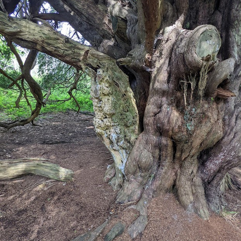
The Yews
The age of yews is notoriously difficult to determine because as the trees age, their trunks becomes hollow which makes ring counting and carbon dating impossible as there is hardly any old wood left. Added to this, yews have this unusual ability to arrest their growth for centuries on end if conditions are unfavorable, until the environment becomes favorable again which reawakens the tree, and it starts growing again. During these years, the tree stops adding tree rings and girth to its trunk. Determining the age of yews is, hence, mostly guesswork. There are claims as high as 5,000–9,500 years, but these values are unrealistic.
According to local legend the yews at Kingley Vale were planted as a memorial for a battle fought between the Vikings and the Anglo Saxons in the year 859, but some sources claim the trees are two thousand years old.
Nevertheless, the survival of the Kingley Vale yews is remarkable because most ancient yew trees across Europe were felled after the 14th century when English bowmen started preferring staves to be made from straight-grained yew wood, which is reputedly the hardest coniferous timber in the world. This wood was imported by royal decree with barrels of wine from Portugal and Spain.
Kingley Vale is one of the few major groves of yews remaining today. The Ancient Yew Forest of Kingley Vale | Amusing Planet
The grove of Yews in the valley below Bow Hill/Stoughton Down is a remarkable space. The forest floor is bare and covered in needles from the yews. The trees have grown into architectural shapes. Kinsley Vale is the largest area of Yew in the UK. The dense shade of the canopy does no permit much plant, bird or invertebrate diversity. The width of the trunks and the thickness of the canopy makes a walk through the grove feel like being in a vast columned building, like a cathedral or mosque.
Yew Taxus baccata woodland occurs on shallow, dry soils usually on chalk or limestone slopes, but in a few areas stands on more mesotrophic soils are found. The habitat is classified as NVC type W13 Taxus baccata woodland. Within this community yew tends to be overwhelmingly dominant and is usually associated with a very sparse shrub and tree layer. Only a few species, such as dog’s mercury Mercurialis perennis, can survive beneath the dense shade cast by the canopy of mature yew trees. Yew-dominated woodland (Taxus baccata woods of the British Isles) - Special Areas of Conservation (jncc.gov.uk)


Goosehill Camp
On Stoughton Down/Bow Hill, to the north east of the main yew grove are more yews; these yews cover Goosehill Camp (Iron Age). The earthworks of Goosehill camp are barely discernible under the yews.
From Historic England's listing A multiple enclosure fort known as Goosehill Camp and a prehistoric linear boundary on Bow Hill, West Dean - 1008375 | Historic England::
Beneficial land use over the years has enabled Bow Hill and Kingley Vale to support one of the most diverse and well-preserved areas of chalk downland archaeological remains in south eastern England. These remains are considered to be of particular significance because they include types of monument, dating from the prehistoric and Roman periods, more often found in Wessex and south western Britain.
The well-preserved and often visible relationship between trackways, settlement sites, land boundaries, stock enclosures, flint mines and funerary monuments in the area gives significant insight into successive changes in the pattern of land use over time. Multiple enclosure forts comprise two or more enclosed areas measuring up to 9.6ha, generally defined by sub-circular or sub-rectangular earthworks spaced at intervals which exceed 15m. The inner enclosure is usually entirely surrounded by a bank and ditch. They date mainly to the Late Iron Age (350 BC-c.AD 50), and usually occur in south western England on sloping ground. Most are sited on hillslopes overlooked by higher ground near a water supply, and many were used for periods of up to 250 years. The outer enclosures of multiple enclosure forts are usually interpreted as areas set aside for the containment of livestock, whilst the inner enclosure is generally thought to have been the focus of occupation. The earthworks usually include a bank with an outer, V-shaped ditch 1m-3m deep. Entrances are generally a single gap through each line of defence, often aligned to create a passage from the outer to the inner enclosure, although there are a few examples where entrances through successive earthworks are not in alignment. ...
Their construction spans the millenium from the Middle Bronze Age, and they were generally used to mark important boundaries in the landscape, defining and ordering the territorial holdings of those groups who constructed them. Despite some limited modern disturbance, partial excavation and tree-root damage caused by scattered woodland cover, the multiple enclosure fort and earlier linear boundary on Bow Hill survive well and contain archaeological remains and environmental evidence relating to the monument and the landscape in which it was constructed. The clear superimposition of the fort on the earlier linear earthwork will provide evidence for the development of land use on the hill over the prehistoric period.
The monument includes the ramparts, ditches, entrances, ancillary banks and internal areas of a multiple enclosure fort, situated on sloping ground just below the summit of a ridge of the Sussex Downs. An earlier, prehistoric linear ditch and bank which runs beneath and either side of the south western portion of the outer ramparts of the fort/ ...
The monument was partially excavated between 1953 and 1955, when the rampart ditches were discovered to be V-shaped and originally 1.4m deeper than their present level. Finds from the ramparts included Iron Age and Roman pottery sherds and a bronze brooch dating to the first century AD. Partial excavation of the circular depressions in the inner enclosure showed them to be the sites of at least three small Iron Age buildings. Postholes, fragments of daub and charcoal were among the items found. ... A multiple enclosure fort known as Goosehill Camp and a prehistoric linear boundary on Bow Hill, West Dean - 1008375 | Historic England

Goosehill Camp under the Yews:


Bracket Fungus on two of the Yews


Butterflies
The escarpment of Stoughton Down, north of the Yew grove, provides a habitat of unimproved chalk short grassland which is ideal for chalkland butterflies.
Red Admiral

Large Whites


Meadow Brown

Common Blue

Brimstone


Common Blue

Brimstone

Six-Spot Burnet Moth

Burnet Companion Moth

Common Blue

Holly Blue


Meadow Brown


Common Blue


Common Blue

Female Common Blue

Common Blue

Green Hairstreak


Brimstone


Painted Lady

Dragonflies
Broad-Bodied Chaser


Exuvia (discarded exoskeleton of the above Broad-Bodied Chaser

Other insects
Common Water Strider

A pair of "jewel" beetles mating; these are beetles of the Anthaxia ("Jewel" beetles) genus, species unknown

Tadpoles in the dew pond

Birds
Great Tit

Great Spotted Woodpecker

Mistle Thrush


Buzzard


Pheasants

Kestrel


Blackcap with insect


Pheasants

Scenery and Views
Stoughton Down

Dew Pond

Looking up to Stoughton Down; this grassland was full of butterflies

Looking down from the top of Stourton Down to the dew pond with the yew grieve in the background

From the top of Stoughton Down
The Isle of Wight, the Solent, Hayling Island, Chichester Harbour Thorney Island

Chichester Harbour and Thorney Island

Chichester Island

Dell Quay, Fishbourne Creek (Chichester Harbour)

The Yew Grove and the coast in the background

A memorial to Arthur George Tansley

Tansley provided his generation of botanists with a vehicle for exchanging information and opinion when in 1902 he founded the New Phytologist. He was only 30 years old. His influence grew steadily and he is now recognised as the father of British ecology.
His drive helped found the British Vegetation Committee, which in 1913 evolved into the British Ecological Society. He was its first President and soon Editor of its Journal of Ecology. He served immediately after WWII on the government committee looking at the establishment of national nature reserves. The outcome was the establishment of the Nature Conservancy in 1949. Tansley was its first Chairman. He was already President of the Council for the Promotion of Field Studies (now the Field Studies Council). Sir Arthur George Tansley, 1871–1955 (newphytologist.org)
Tansley’s paper, ‘The problems of ecology’, given over to botanical survey, at the British Association’s annual meeting of 1904, became British ecology’s foundation-paper. Tansley and Ecology - Sir Arthur George Tansley, 1871–1955 (newphytologist.org)
Devils Humps
The Devil's Humps (also known as the Kings' Graves), the two bell barrows and two pond barrows on Bow Hill, Stoughton Down, are situated on a downland ridgeway crossed by an ancient trackway, above Kingley Vale.
Historic England: Beneficial land use over the years has enabled Bow Hill and Kingley Vale to support one of the most diverse and well-preserved areas of chalk downland archaeological remains in south eastern England. These remains are considered to be of particular significance because they include types of monument, dating from the preshistoric and Roman periods, more often found in Wessex and south western Britain. The well-preserved and often visible relationship between trackways, settlement sites, land boundaries, stock enclosures, flint mines, ceremonial and funerary monuments in the area gives significant insight into successive changes in the pattern of land use over time. Round barrow cemeteries date to the Bronze-Age (c.2000-700 BC). They comprise closely-spaced groups of up to 30 round barrows - rubble or earthen mounds covering single or multiple burials. Most cemeteries developed over a considerable period of time, often many centuries, and in some cases acted as a focus for burials as late as the early medieval period. ... Bowl barrows, the most numerous form of round barrow, date from the Late Neolithic period to the Late Bronze Age and occur across most of lowland Britain. Often superficially similar, although differing widely in size, they exhibit regional variations in form and a diversity of burial practices. Despite evidence of partial excavation, the two bowl barrows on Bow Hill survive well and contain archaeological remains and environmental evidence relating to the monument and the landscape in which it was constructed. The barrows, along with two bell barrows and two pond barrows to the south west, form part of a linear round barrow cemetery, partly enclosed by a series of linear earthworks constructed across the three limbs of the Y-shaped hill. These monuments are broadly contemporary and their close association will therefore provide evidence for the relationship between land division and funerary practice during the period of their construction and use. Two bowl barrows on Bow Hill forming part of The Devil's Humps round barrow cemetery, Stoughton - 1008372 | Historic England

The second of the fourth barrows appeared in In the 1971 in the Doctor Who story The Daemons. The nearby Aldbourne village played the part of the village Devils End, Visiting Devils End & The Devils Hump - Aldbourne Heritage Centre


The walk back to Chichester
Rather than get the bus I walked back to Chichester. From The north west part of the reserve, Goosehil Camp, I walked down a path, to the B2141. After a short walk down the B2141 (no pavement or verge, so not a route I recommend) I walked over a foot path eastward to join the Centurion Way at Mid Lavant, and then walked down to Centurion Way to Chichester Station
As I walked on the footpath to the Lavant Valley I turned a bend in the path and saw what I thought was part of a part of kite on the ground and thought it must be a family playing with a kite in the afternoon sun. Then I realised it was a Red Kite eating carrion. It left its meal as soon as it saw me.

Sheep in the Lavant Valley


The river Lavant is quite short, so it is never particularly wide. It rises in East Dean and runs through Singleton, West Dean, Lavant and Chichester; the Romans diverted it to flow around the walls of Chichester and then west into Chichester Harbour; it is now culverted underneath the city centre; there was serious flooding in Chichester in 1992 when the culvert became blocked. There are very few rivers in Sussex, as water tends to pass through the chalk, as it is porous. The Lavant is a winterbourne, a river that is typically dry through the summer months; winterbournes are a feature of Sussex. Considering the lack of rain we have had of late I was surprised that it had water in it. The Lavant's water looked very pure; you could see through it's shallow depth to the river floor.
The valley just above the villages of Lavant (there are three), in the afternoon sun, with its sparking waters, sheep, ducks and Water Crowfoot (a type of daisy that grows in streams), felt like a rural idyll, a vision of a Sussex dominated by pastoralism, wild flowers and rolling downs; but it was probably never really like that. My vision of rural Sussex was formed by walking over the downs at Rottingdean when my Grandfather looked after the farm at St Mary's Covent at the weekends in the 1970s and watching Jack Hargreaves' "Out of Town" (on the old Southern, now Meridian, ITV); the 60s and 70s TV series about the countryside, rural life and traditions in Sussex and Hampshire; his style was consciously nostalgic for a lost rural idyll.

Ducklings and Water Crowfoot


Sheep and Water Crowfoot


The Centurion Way
The Centurion Way is a 5.5 mile (9km) path that runs between Chichester, Lavant and West Dean following the old dismantled Chichester to Midhurst railway line, which closed in 1991. Centurion Way Railway Path - West Sussex County Council

A Robin, on the Centurion Way


Mallard Duck and ducklings in the Lavant. The Centurion Way run in parallel the Lavant, sometimes it is close to the river, mostly it is a few meters away


Mobile metal animals, drawn by local school children before being enlarged and reproduced in steel sheet. Centurion Way | Pier to Pier Trekking


"The Chain Gang"

Members of “The Chichester Road Gang” by David Kemp. Made from empty oxygen gas cylinders, together they make up a ganger in a bowler hat, a gang of workers with spades and a surveyor with a theodolite. They are placed where an historic Roman road to Silchester crosses the path of the old railway line. CDC 2218 DL Template AW (chichester.gov.uk)

The surveyor and a Blue Tit

The Blue Tit nesting in the Surveyor's "eye"


Robin

Sculpture

Fox

Mistle Thrush

Blackbird

Chichester's new Jubilee Country Park; the Centurion Way goes past it.

The 40-acre plus country park has been named the ‘Platinum Jubilee Country Park’ in honour of Her Majesty’s 70 years of service, and was jointly created by new homes builders, Miller Homes and Vistry Group.
Over 13,000 trees have also been planted in the new park by the two housebuilders, encouraging new wildlife to settle and flourish, with the ambition of helping to future-proof the environment. ...
Tracey Forbes-Taylor, regional managing director of Miller Homes Southern, said: “The launch of Jubilee Country Park is the culmination of months of hard-work from our entire team, and the perfect way to celebrate their efforts.
"We’re incredibly proud to have been able to bring this plan to fruition, not only creating a peaceful green space for Chichester residents to enjoy but also helping neighbouring wildlife to thrive.

Tufted Ducks and Herring Gulls in Jubilee Country Park


Starlings on the new railings of the park


Comments